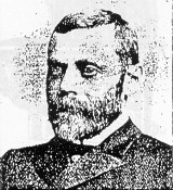
TOWN NAMED FOR O.H. MANNING
The town of Manning was named in honor of Orlando H. Manning who had a checkered career ranging from schoolteacher, newspaper publisher, lawyer, to politician.
In 1881, the 33 year old Manning was attorney for the Iowa southwestern branch of the Chicago & NorthWestern Railroad. As such, he handled the transaction of land for the Western Town Lot Company, which purchased the prairie farm land and sold it to Manning for city lots.
Born in Indiana in 1848, he came to Adel with his family 1854. After studying at Western College in Linn County, he moved to Jefferson to teach school. He received his legal training in Jefferson; in 1868, he was admitted to the bar and located his offices in Carroll.
A crusader who "detected irregularities in the county government," Manning purchased the Carroll Herold in 1877. Through his role as newspaper publisher, he attempted a general housekeeping of the local government.
His first political office was that of County Treasurer. At the age of 28, he was elected to the Iowa Legislature. During his second term, he was appointed chairman of the House Committee on Rail Roads. In 1881, he was nominated for the office of Lieutenant Governor of Iowa, and served that position for two, two-year terms.
He was known for his brilliant political record, his skill as a leader, and by his strength as a debater.
In 1885, he accepted the position of Legal Counsel for the Central National Bank of Topeka, Kansas; from there, he went to Denver, Colorado, as the attorney for the Atchinson, Topeka & Santa Fe Railroad. In 1889, he moved to Chicago, Illinois, to take charge of the legal interests of a number of Illinois corporations, under a 15-year contract. He spent his remaining years there.
GEOLOGICAL FORMATION
The Manning landscape is the result of many geological processes and their interaction with both the hydrologic and biological processes. Manning is located in what is known as the Southern Iowa drift plain with topography of steeply rolling hills interspersed with areas of level alluvial low-lands along larger streams. Manning is located near the divide between the Mississippi River Basin and Missouri River Basin, which is one of the major drainage divides in the United States. Water from the Manning area flows into the West Nishnabotna River and then into the Missouri River.
The topography of steeply rolling hills resembles ocean waves with seldom an extensive vista because the elevations of the crest of the hills are approximately the same. Basically, this topography is a result of the glacier deposits and loess deposits on the bedrock of the area. Drill log records from a well to the south of Manning indicate that the bedrock surface is 365 feet below the land surface and consists of Pennsylvanian rocks of the Des Moines series. These Pennsylvanian rocks consist mostly of shales with interbedded limestones and minor coal units. Other well log records indicate that a sandstone of the Cretaceous system of the Dakota formation also makes up bedrock of the area.
Little evidence remains to indicate an association of this region with continental glaciers. Knowledge of these massive sheets of glacier ice comes from the tens of feet of glacial drift carried by the ice and deposited on the bedrock surface. This drift consists of glacial till belonging to the Nebraskan age on top of which Kansan age drift was deposited.
Since Kansan time most of the land has been exposed to stream erosion, weathering processes, soil development, and loess deposition. The drainage patterns we now see had their origin on the glacial deposits. At times it is possible to see red zones or reddish brown zones on the hillsides or in fresh road cuts. This material is a result of oxidation of iron and is an ancient soil profile or paleosol developed on the Kansan till surface.
During the latter part of the Pleistocene, loess, a wind-blown material of uniform particle size, was deposited over the glacial till. This loess is thickest to the west of Manning and thins to the east, the source being the Missouri River Valley. The high fertility soils of the area were derived from the loess and are mainly of the Marshall series.
I CAN REMEMBER---
Going to the variety store and getting a penny's worth of this and a penny's worth of that in the candy department. There were fat chocolate drops, chocolate cigars, candy bananas, a candy fried egg in a small tin skillet, licorice, clear rock candy, candy ice cream cones, etc.
---Grace Andresen