The following information & pictures and conclusions are based on past experience of the days we use to till our farms as compared to almost 20 years of No-till experience on them now. So the conclusions are using apples to apples examples in many cases.
We know how severe our fields washed and where they washed the most when we used tillage from 1980 on back. We have been learning all kinds of new things the last 20 years which helps us understand what is involved with soil structure.
The EPA/environmental people basically have little if any actual farming experience.
They also have an agenda and can get all kinds of support from activist groups that also have agendas. These people have the time, resources and money and some use non-scientific evidence and "half truths" to convince the general public and politicians that their proposed regulations need to be inacted.
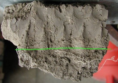
The image below shows the clay silt layer that has collected in the last 10 years on our continuous No-Till flood bottoms.
Note the green line --- above the green line is a 2.5 inch layer of clay. The soil that is washing down from upstream is no longer the good topsoil but subsoil clay from the sidehills.
The darker soil below the line use to be the topsoil of the field a little over 10 years ago. Since we no longer use tillage we don't mix the silt that floods into the bottoms hence this layer of clay is now choking our bottom ground.
Nightcrawlers will eventually mix this clay silt but they can't keep ahead of all the flooding that occurs anymore.
Also take note where the roots are growing and the porous texture of the soil below the green line.
The facts are everywhere.
We all see the eroded sidehills and muddy water in the creeks.
We can sit back and continue with our ways of the past or start changing our farming practices now.
Below you'll see the facts and why many more strict laws will be enacted (unless we act now -- voluntarily). Ag programs may eventually require No-Till & CRP filter strips and the use of precision ag technology.

View of Kusel creek April 26 with clear water and May 2 after 1.5 inches of rain up north when erosion of tilled fields has polluted the water with sediment and ag land pesticides.

Above: April 26, 2001 creek on Kusel farm
The dirt you see covering the grass is soil that was left behind with the snow banks from winter wind erosion blown off of tilled fields.

Above: Same area as picture to left --- May 2, 2001 creek after 1.5 inches of rain up north.

We started adding CRP filter strips 15 years ago.

Stable creek banks with grass down to the water level and CRP filter strips will be a part of solving the erosion issue.

CRP along creek

Brown water from run-off of tilled fields.

May 2, 2001

May 3, 2001 erosion pictures